We have all used VFR, (Visual Flight Rules), sectional charts for flight planning. These charts hold an immense amount of information and are really fun to lay out on a table or floor for your upcoming trip. Are VFR Sectional Charts Important For Flight Planning?
Are VFR Sectional Charts Important For Flight Planning?
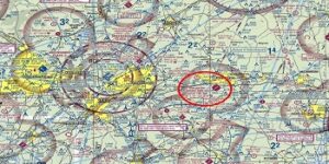
VFR Sectional Charts are essential for flight planning and are full of information, giving us a visual idea of obstacles and terrain along our route. Flight Data, Check Point, Airport information with radio frequencies, and airways are a few of the many items present on sectionals.
Are VFR Sectional Charts Important For Flight Planning?
1. What Is A Sectional Chart?
Sectional charts are the heart of the VFR flight planning tools. They are on a scale of 1 to 500,000 or 8 statute miles per inch. This allows for extensive information to be placed on the chart. They are laid out in latitude and longitude.
There are sectional charts for wherever you wish to fly which includes Alaska and Hawaii, (including American Samoa, Guam, and Mariana charts on the reverse of the Hawaiian sectional), and all U.S. Charts are available for purchase from the FAA,here.
We can acquire Canadian charts here.
Most pilot stores and online stores carry both digital and paper charts.
Charts are published by the FAA every 56 days and 50 charts are available.
2. The Chart Ledger.
You can get a lot of information by studying sectional charts while learning to decipher the symbol meanings. I recommend everyone take time on sectionals.
Take the time to study the surrounding area on each side of your course while plotting the individual legs. Note the airports along the way so you have a place to land safely if a need arises.
It is just nice to know obstacles on the route so you don’t get surprised as I once did flying to Chadron, Nebraska. I discovered a radio tower that looked like it never stopped going up. The towers are lit by strobes and they could save you if you are flying below the top.
Read the ledger and enjoy what you learn.
3. Flight Planning.
Laying out your courses from fix to fix, and learning to navigate through the sky is a huge thrill and for me, it opened up a new world. I could go places and get there fast without getting lost.
Along came RNAV or area navigation, which lets us move waypoints for direct routes. That new gadget called GPS changed the world by allowing us to fly direct with the push of a button called a GOTO. How cool is that?
Be advised that the GOTO feature can get you into trouble. Be sure that your new course will provide you with adequate terrain clearance or not place you in airspace that you should not be in without clearance.
All the cool gadgets still have to go by the wayside so that we can all understand navigation and flight planning.
We have great tools for doing that and Private Pilot Kits from any supplier will give the charts, plotter and the E6B, and your reading/reference books. You will also have a test prep for the written exam.
4. Types Of Charts.
Relevant charts for VFR traffic are the Sectional chart and the Terminal area chart. Other charts are specific to areas. If you fly in the Gulf Coast, Caribbean, or Grand Canyon you can retrieve those charts as well.
The Terminal Area Chart has much more information and in greater detail so that you can be better equipped for transitioning, arriving or departing Class B airspace.
These charts are relative to medium to slow aircraft and are not for flying in Instrument metrological conditions.
Conclusion:
VFR flying is a true privilege that gives way to an incredible way to explore the world. It is truly an important part of freedom. It opens up places you would not be able to easily explore without a tool like an airplane.
Charts are really helpful for all kinds of information. You can find fun backcountry strips to allow you access to places you would likely never go. I loved flying into those airstrips and meeting a lot of like-minded people.
When you plan a trip to a city, all the needed information is in your hands and on the chart. I carried a small book that was about the airport. It contained all the runways and fuel facilities..
These charts are all you need to see the country. Fly Safe and have FUN.
Please leave a comment or thought.